Home » English version
Irrigation systems in Lombardy plain
Lombardy is located in the north of Italy, in the middle of the Po river water basin; half of its territory is made from mountains, in particular the Alps, and the other half is covered by Padana plain, which is the most important plain in Italy not only in terms of dimensions but also for the agricultural production.
Lombardy was the first in Italy and even in Europe to begin widespread construction of innovative hydraulic systems for the use and drainage of water as well as canals for the regulation and distribution of water. These infrastructures, built over the centuries starting from the Middle Ages, have made the otherwise dry plan suitable for agriculture. This is why today we can rely upon a network made of 40’000 km of artificial canals.
In addition to their irrigation function, most canals have a mixed function of land reclamation, intended as the removal of excess water, also thanks to several pumping stations that ensure hydraulic safety.
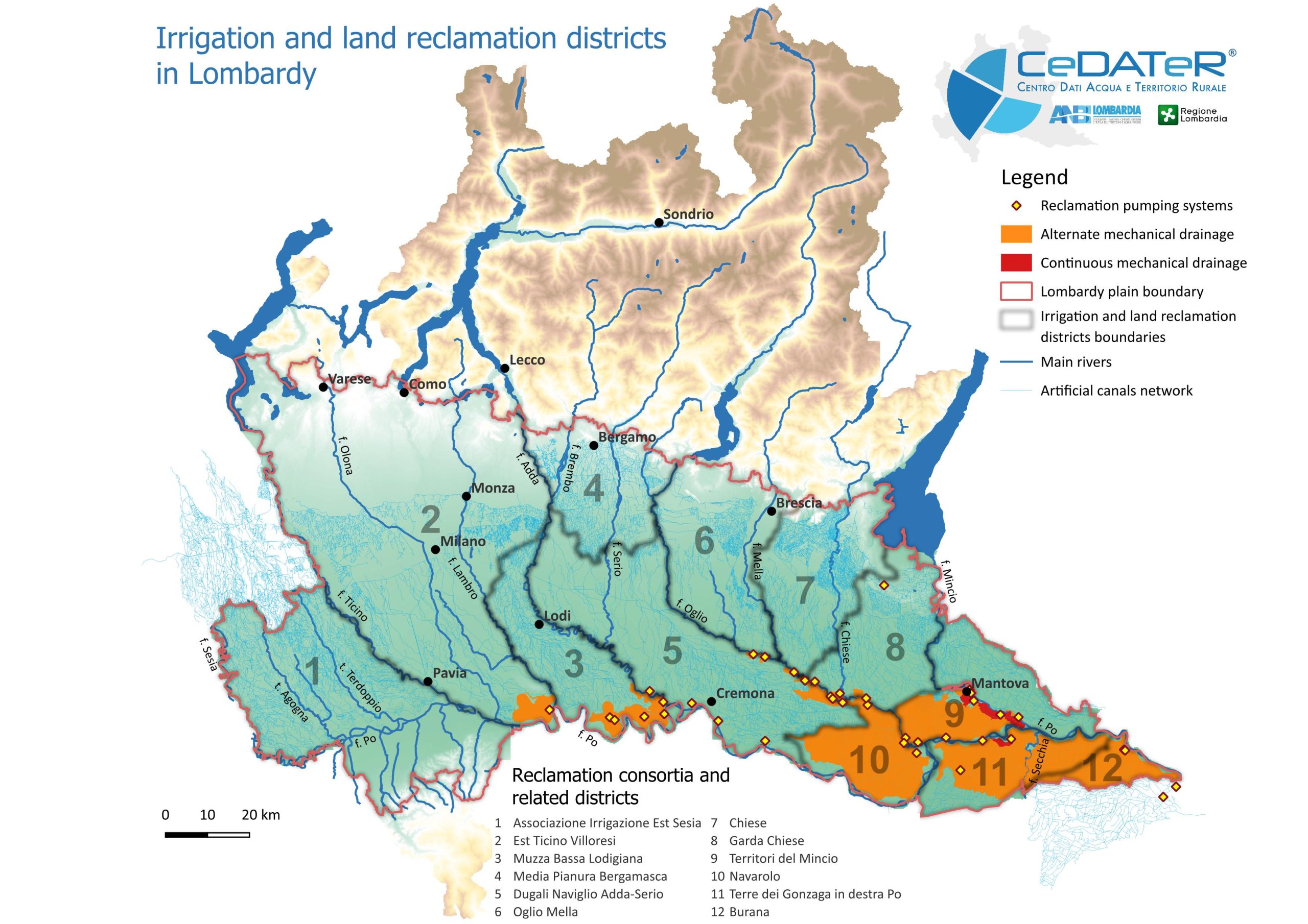
The Lombardy plain covers an area of 1,348,000 hectares, equivalent to 56% of the regional total, of which 837,000 hectares are agricoltural; within these 654,000 hectares are irrigated. In addition to water from the Alpine and pre-Alpine reservoirs, the main water reserves are the five large natural pre-Alpine lakes (Maggiore, Como, Iseo, Idro, and Garda), which drain Lombardy’s major rivers (Ticino, Adda, Oglio, Chiese, and Mincio). Their flow is controlled by the Regulation Consortia, which manages the storage and distribution of the available water resources.
Sources of water for irrigation and surfaces
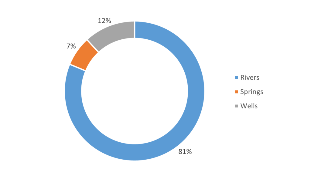
There are approximately 2,800 diversions from rivers with an average flow rate of approximately 850 m3/s during the irrigation season, from April to September. Additional water sources include approximately 700 springs, called “fontanili”, for a total flow rate of 67 m3/s, which are mainly fed by excess irrigation water from upstream areas and represent an excellent example of reuse.
In addition to surface water sources, in some areas irrigation water is drawn from the aquifer via irrigation wells, which are necessary where supply from consortium irrigation networks is difficult or insufficient. Wells data is very fragmentary and incomplete, but an estimated 9,000 irrigation wells exist throughout the region, with an average licensed flow rate of 113 m3/s.
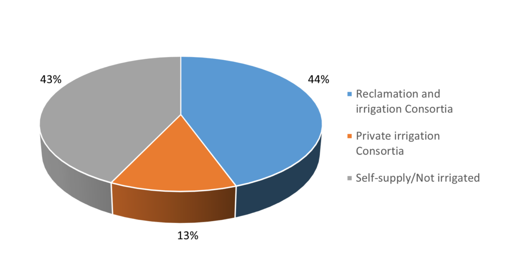
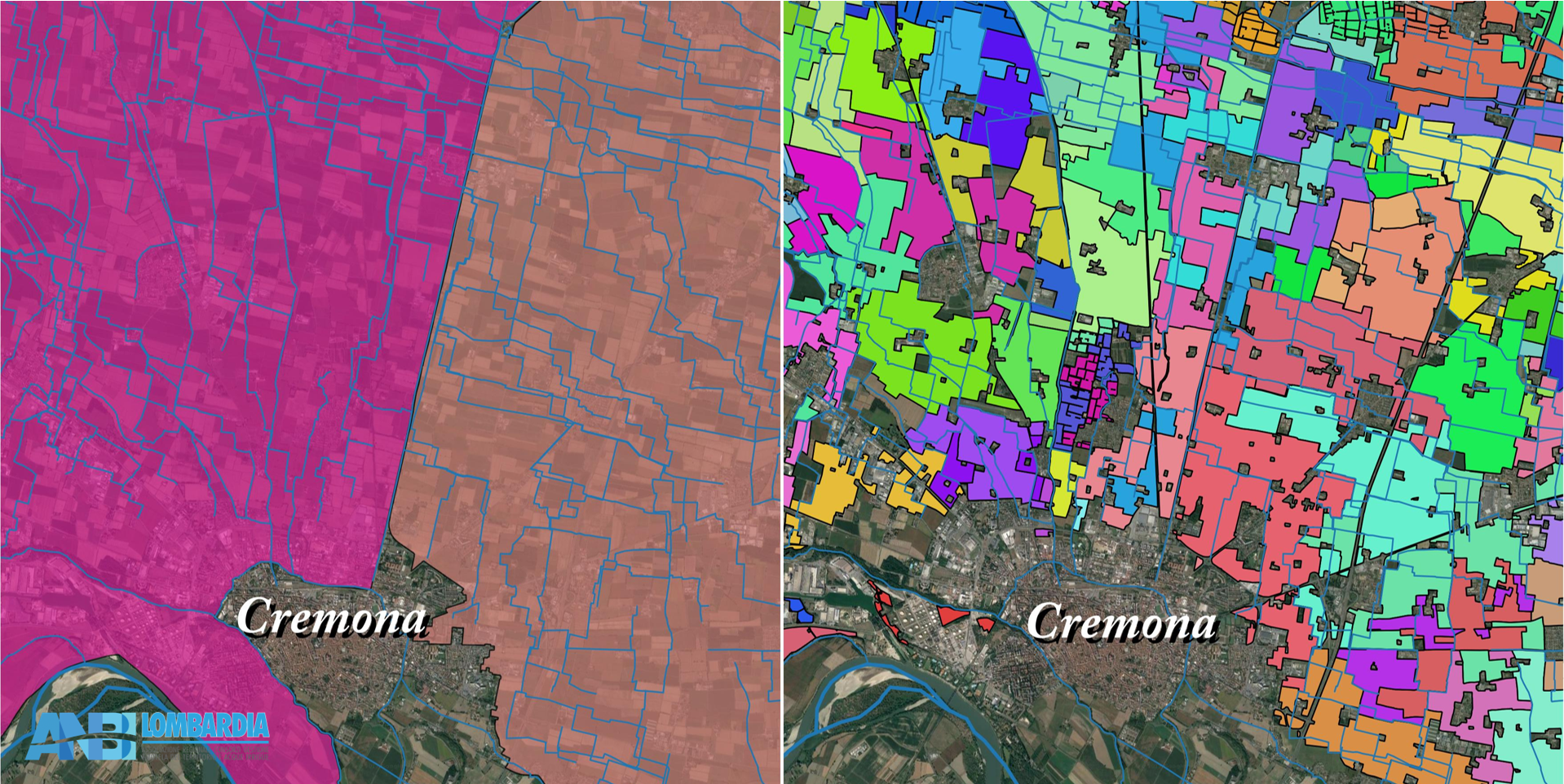
Not all the agricultural territory is irrigated in the same way and we can distinguish into districts managed by collective water boards, such as 12 public reclamation and irrigation Consortia (for an amount of 372’000 hectares) and approximately 450 private irrigation consortia (for an amount of 106’000 hectares): they manage both the intake structures and the canal networks. This type of organization is found on a total of 478’000 hectares, equal to 57% of the agricultural surface area of the Lombardy plain.
In the remaining 359,000 hectares of agricultural land (43%), any irrigation is managed directly by individual farms with independent water supply licences; in these cases, irrigation is defined as self-supply and affects the remaining 43% (358,000 hectares).
Reclamation and irrigation Consortia
Reclamation and irrigation Consortia are public associations comprising mainly private subjects who benefit from irrigation and soil conservation in a specific area. They are governed by a statute approved by the Lombardy Region and form an integral part of the region’s territorial governance system. Their main goal is ensuring sustainable and integrated water resource management trough important activities:
-
irrigation: building and managing the hydraulic infrastructures for the diversion and supply of water for the irrigation of 450,000 hectares of land
-
land reclamation: protecting land from floods and transforming swampland to make it safe and productive
-
hydropower generation and industrial supply
-
ecosystem services: preserving environment and rural landscape, promoting sustainable tourism and soft mobility along canals and infrastructures
Land reclamation and hydraulic safety
The rural hydrographic network has a variety of functions in addition to irrigation. It is in fact the basis of a complex system of hydraulic protection actions, which over the centuries has made it possible to drain and restore ponds, swamps and areas periodically submerged by water due to excessive rainfall or overflowing rivers, making them cultivable and habitable. The function that reclamation works continue to perform today is fundamental for both rural and urban settlements and can be traced back to two main types of reclamation systems:
-
reclamation by natural drainage: in most of the Lombardy plain water is removed using a system of canalizations, mostly promiscuous, in which gravity leads the excess water into the rivers that act as final outlets;
-
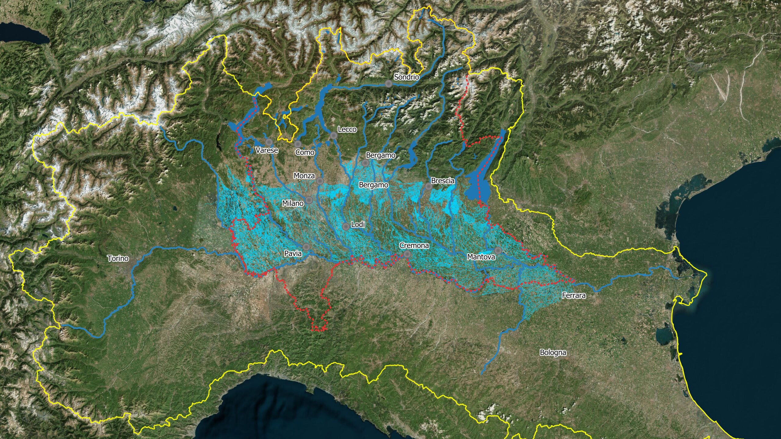
reclamation by mechanical drainage: mainly in the areas of the lower plain the land may be, temporarily or constantly, at lower altitudes than those of the natural water bodies used for final drainage. The removal of water here can only be carried out with the use of 39 pumping systems capable of raising almost 300 m3/s of water to serve territories that extend over an area of more than 190,000 hectares (of which 134,000 in Lombardy). A distinction is made between areas with alternate mechanical drainage, which is only necessary in correspondence with high rainfall (in orange on the overview map) and continuous mechanical drainage, which is instead required continuously throughout the year (in red).
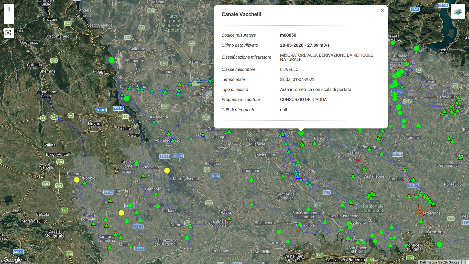
CeDATeR, the irrigation data centre
CeDATeR (Water and Rural Territory Data Centre) is a data centre managed by ANBI Lombardia since 2017. It builds a centralized and standardized system of irrigation-related data for Lombardy, bringing together, for the first time in Italy, public authorities (Regione Lombardia, funder of the project), public water boards and universities.
The main objective of CeDATeR is supporting efficient, shared and data-driven water governance.
CeDATeR carries out numerous activities, including:
-
managing georeferenced irrigation data, such as sources, irrigated areas, canals network, returns
-
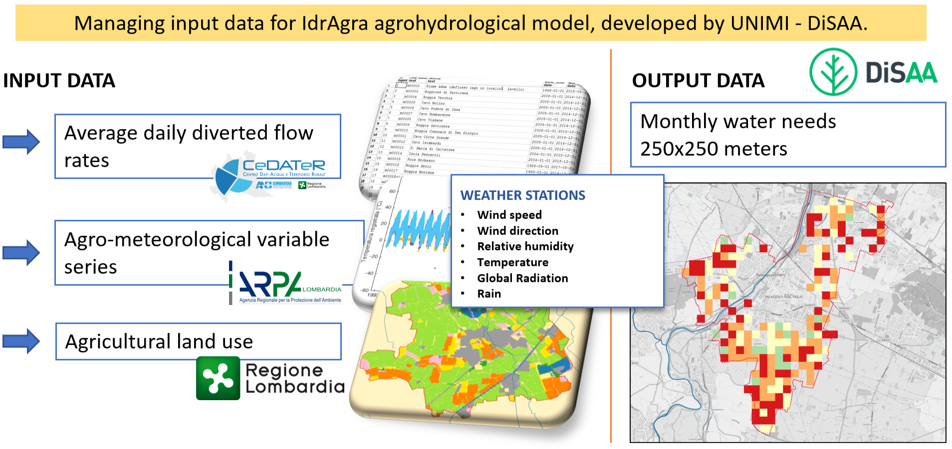
managing the regional irrigation flow monitoring system, that collects the average daily flow rate from more than 440 meters. For sources and districts not monitored, CeDATeR provides an estimation of the volumes used through IdrAgra agrohydrological model, developed by UNIMI - DiSAA and simulating the irrigation needs
-
collecting meteorological data from 130 weather stations of the public monitoring network (ARPA), from irrigation Consortia and from other entities
-
providing data for the regional hydrological balance, in order to update the Water Protection Plan and make more sustainable the future use of water
-
giving support to public authorities for the management of drought events, providing real-time water withdrawal data
-
studies to improve irrigation efficiency or to find new sources of water, such as the identification of the most suitable disused quarries for the function of water reserve tanks and/or for flood lamination
-
annual pubblication of Report on the irrigation season
CeDATeR is Open-source!
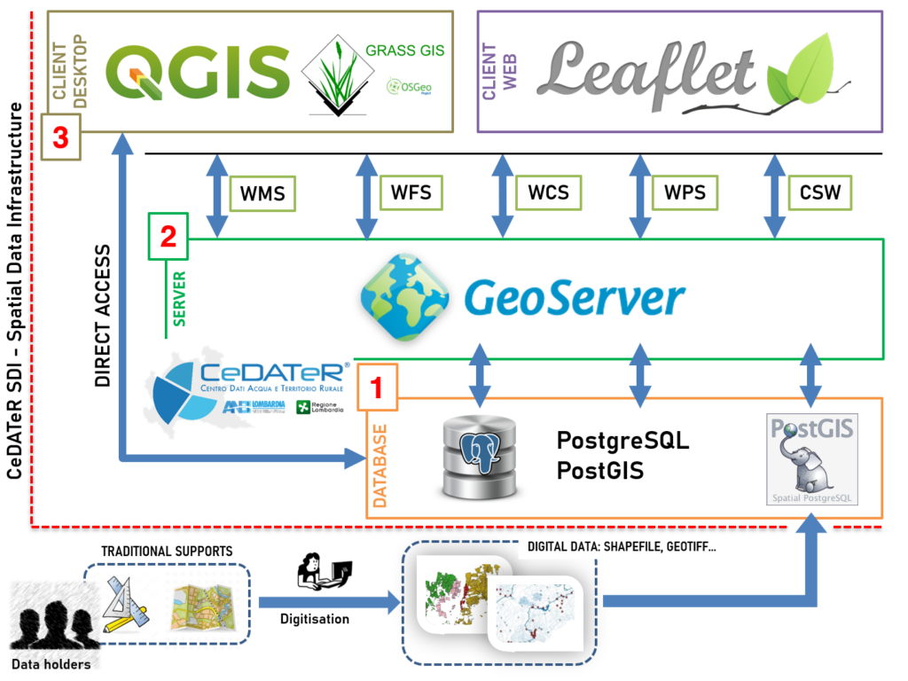
CeDATeR relies on a Spatial Data Infrastructure integrating:
databases for data storage (PostgreSQL, with spatial extention PostGIS), server for data distribution (GeoServer) and GIS tools for visualization and analysis, both desktop (mainly QGIS) and web tools (Leaflet webGIS). The whole system runs with Open Source GIS technologies (GFOSS), ensuring:
-
interoperability
-
flexibility
-
cost efficiency
The CeDATeR model can be easily replicated and adapted to the needs of any organization looking for the best technologies available in terms of performance and sustainability.